🔎 TL;DR
- Every legitimate Progreso waverunner ride launches from the Malecón Tradicional or the adjacent concession beach east of the cruise pier — those are the only spots the SEMAR Capitanía de Puerto de Progreso recognises for motorised water-sports concessions.
- The signature route runs Malecón → Chicxulub Puerto → return, about 16 km east one-way, or roughly 32 km round-trip on a Yamaha WaveRunner VX or Sea-Doo GTI — and yes, you are riding over the literal edge of the Chicxulub impact crater.
- The shorter Malecón → Chelem → Chuburná Puerto westbound loop is the calmer option: 12 km one-way, sheltered behind the long sand bar, and it ends near the protected Ciénaga mangrove channels.
- The open-Gulf offshore extension — running 6–10 km north of the coast — is technically possible on flat-calm summer mornings, but it is the route where things go wrong because Gulf conditions change fast and the shoreline disappears past 8 km.
- Fuel range on a stock VX or GTI at touring throttle is ~60 km / 35 nm; the full Chicxulub round-trip uses 50–60% of the tank, which is why operators top off before launch and keep an escort boat in the loop on long-format rides.
- Anchor stops happen at Chicxulub beach (sand, public beach, kiosk for water) and at Chelem dock — never on seagrass, which covers most of the shallow shelf and is protected under NOM-059-SEMARNAT.
Where you launch — the Malecón is the only real option
Progreso is a port town, not a resort town, and that single fact shapes everything about how waverunner rentals work here. There is no Médano-style beach concession arc with twelve operators competing for tourists. Instead, motorised water-sports concessions cluster along a 1.5 km stretch of the Malecón Tradicional — the seaside boardwalk that runs east from the cruise pier — and at the small beach adjacent to the public pier known locally as the muelle viejo. The Secretaría de Marina through the Capitanía de Puerto de Progreso, plus the federal port-administration agency AFAC for coastal aviation overflight coordination, oversee what gets a concession and what does not.
If somebody on a cruise day tries to sell you a "private beach waverunner pickup" from a hotel pool deck farther east toward Chicxulub or out past Yucalpetén, walk away. Those rentals are unlicensed, they ride uninsured craft, and they will be the ones the Capitanía boards first when SEMAR runs spot checks — which they do, especially on cruise-ship Tuesdays and Saturdays. The Progreso waverunner rules guide covers exactly which paperwork a legitimate operator carries.
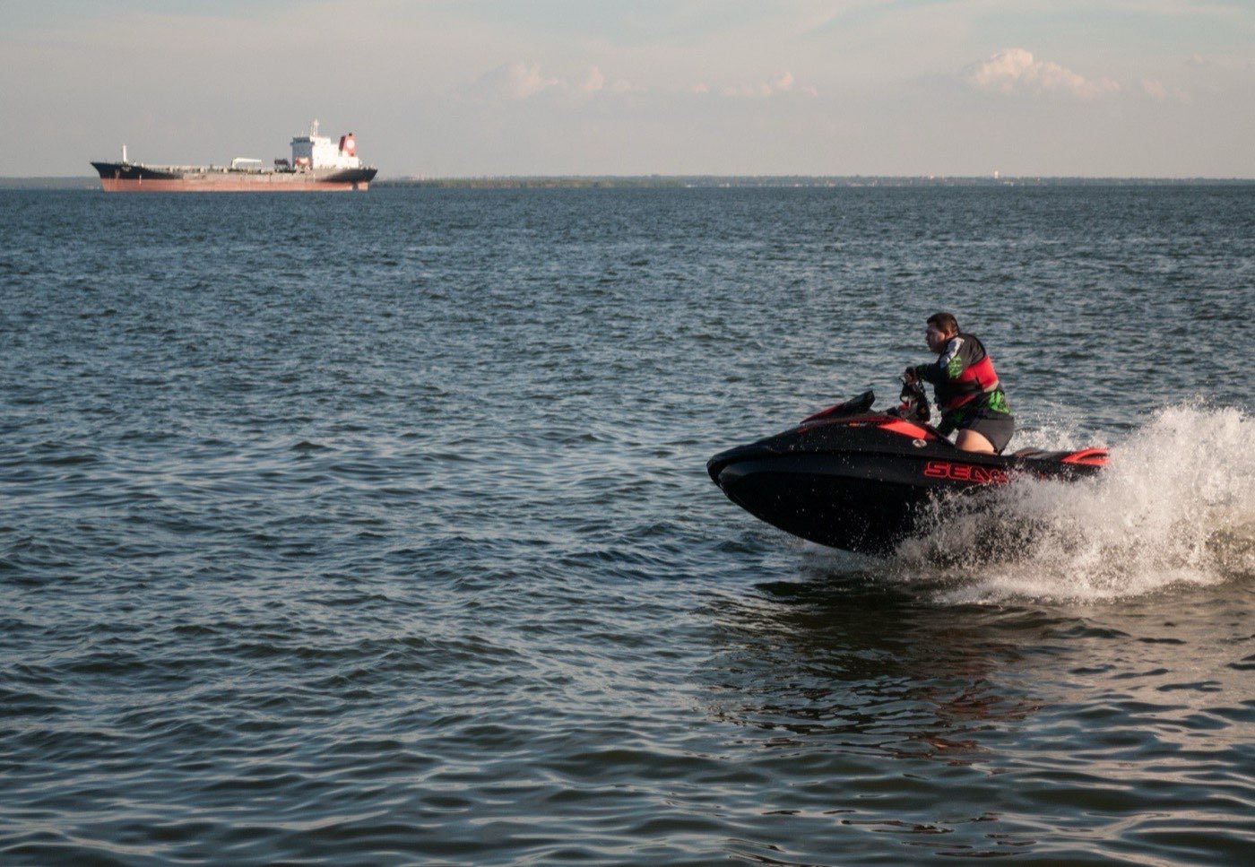
Concession holders here run a smaller, simpler fleet than what you find in Cancún or Cabo. Most operate Yamaha VX Cruiser or Sea-Doo GTI 130/170 three-seat hulls — the workhorse craft for shallow Gulf water. A few of the better operators keep one or two Yamaha FX HO or Sea-Doo GTX 170 units for longer-range rides like the Chicxulub run, where you want the extra fuel tank and the smoother ride at touring throttle. Premium models cost 20–30% more per hour, and on the long-format route they are worth every peso because you will spend over an hour underway.
The corridor in front of the cruise pier
From any Malecón launch, the first 800 metres east of the cruise pier are inside a marked corridor with a strict 5-knot no-wake zone — buoyed by SEMAR, enforced by the harbour patrol that ties up at the inner pier. When a cruise ship is in port (Tuesdays, Wednesdays, Saturdays during high season), the corridor tightens further because tender boats run constantly between the ship and the cruise terminal. Captains who know the bay treat this stretch as a single slow-roll segment until they clear the pier's east end and the water opens up. After that, the throttle opens — but only out to the marked 200-metre swim line, not closer to shore.
Route 1: The Chicxulub crater run — Malecón to the impact town
This is the route people fly to Progreso for. The town of Chicxulub Puerto sits 16 km east of the Progreso Malecón along an almost-straight Gulf-facing beach. It is the namesake town of the Chicxulub impact crater — the 180-km-wide buried crater where the asteroid that ended the Cretaceous slammed into what is now the northern Yucatán shelf, roughly 66 million years ago. The crater itself is buried under hundreds of metres of carbonate sediment and seawater, so you will not see a rim or a hole. What you will see is the monument the town built at the beach, a small plaza, and the kiosk that sells ceviche to weekend visitors.
The geological story is real, though. The NOAA ocean-floor mapping of the Gulf shelf — combined with the Pemex offshore gravity surveys from the 1950s that originally revealed the crater's ring structure — confirms that you are riding directly over the southern half of the impact basin when you cross the line of buoys 6 km east of the Malecón. Sit with that for a second.
What the ride feels like
The Malecón-to-Chicxulub corridor runs roughly parallel to the coast, 200–400 metres offshore, in 1.5–3 metres of water. That is shallow by any standard, and it shapes how you ride. Three things to know:
- Seagrass beds are everywhere. The Gulf shelf here is a Thalassia testudinum meadow, protected under NOM-059-SEMARNAT and important nursery habitat for the Yucatán reef fishery. Captains hold the corridor specifically to avoid impacting the meadows; running outside the corridor at speed kicks up plumes of sediment and damages roots. Do not freelance off the line.
- Chop is moderate but constant. The shallow shelf means short-period waves — 0.5–1.0 m typically, building to 1.5 m on windier afternoons. Less dramatic than Caribbean swell, more relentless. Your wrists will know after 40 minutes.
- Boat traffic thins past the cruise terminal. Past the eastern edge of the Malecón, you mostly see pangas, the occasional sport-fishing boat working the seagrass edge for snook, and the very occasional waverunner from a competitor operator. Open water from a Cancún standard.
Anchor stops on the eastbound run
There are two legitimate anchor points on the Chicxulub route, both at public beach access. Roughly halfway, at the village of San Benito, there is a sandy beach with a small palapa kiosk; some captains stop here for 5–10 minutes if the group wants to stretch. At Chicxulub Puerto itself, the operator anchors offshore in 1.5 m of water and the group wades in for 20–40 minutes — long enough to walk the malecón, photograph the impact-crater monument, and grab a coconut from the beach kiosk. Then back on the craft, throttle west, and ride the prevailing easterly wind home faster than you came out.
Route 2: The Chelem–Chuburná westbound loop
If the Gulf is moody or the group is mixed-skill, the westbound route is the smart pick. From the Malecón, the corridor runs west along the long sand bar that shelters the Ría de Yucalpetén — the artificial cut and lagoon system that hosts the Yucalpetén commercial-fishing port and the small marina at Chelem. About 8 km from the Malecón you reach the Chelem dock; 4 km farther west and you are at Chuburná Puerto, the eastern edge of the Chuburná mangrove system.
This route is calmer because the sand bar acts as a partial windbreak when the wind is north-east, which it is most days. The water is also marginally shallower (1.0–2.5 m) and the seagrass beds are denser, so captains keep the corridor tighter. Expect a slower average pace and more anchor time. The trade-off is scenery: more pastel-coloured fishing villages, fewer dramatic crater monuments.
The mangrove no-entry boundary
One thing the operator briefing will hammer: you do not enter the mangrove channels. The Chuburná–Sisal mangrove belt is part of the Reserva Estatal Ciénagas y Manglares de la Costa Norte de Yucatán, declared by the Yucatán state government in 2010 and managed in coordination with CONANP. Motorised craft are restricted to designated transit corridors only; the inner channels are kayak-and-SUP territory only. A waverunner in a mangrove channel is a sanctionable offence under both NOM-059-SEMARNAT and the state reserve management plan.
Ride the route the locals run — crater, malecón, mangrove edge. Book Progreso waverunner →
Route table — distances, fuel and time per leg
Distances are measured from the Malecón launch point on chart; fuel-use figures are for a stock Yamaha VX Cruiser at touring throttle (4,500–5,500 rpm), reconciled with manufacturer fuel-burn curves and Gulf-shelf chop conditions typical of the Yucatán north coast.
| Leg | Distance (km) | Underway time | Fuel used (L) | Speed cap | Stop |
|---|---|---|---|---|---|
| Malecón corridor → east end of cruise pier | 0.8 | 5 min | ~1.5 | 5 kn no-wake | — |
| East pier → San Benito (mid-point) | 8.0 | 15 min | ~8 | open | Optional 5 min |
| San Benito → Chicxulub Puerto | 8.0 | 15 min | ~8 | open | Yes — 30 min anchor |
| Chicxulub → Malecón (return) | 16.0 | 25 min | ~14 | open | — |
| Crater route round-trip (3h product) | ~33 km | ~60 min underway | ~30–35 L | — | 1 main stop |
| Malecón → Chelem (westbound) | 8.0 | 15 min | ~7 | open | Yes — 15 min |
| Chelem → Chuburná Puerto | 4.0 | 8 min | ~4 | open | Yes — 15 min |
| Chuburná → Malecón (return) | 12.0 | 20 min | ~11 | open | — |
| Westbound loop (2h product) | ~24 km | ~45 min underway | ~22–25 L | — | 2 stops |
The 3-hour Chicxulub product runs roughly 50–60% of a full tank — well inside safety margin. Operators top off at the dock before launch on this route and would never send you out on less than 90% of capacity. The shorter Chelem loop uses about 35% of a tank.
Route 3: The offshore Gulf extension — when and when not
Some operators offer a third option: an offshore run 6–10 km north of the coast into the open Gulf. The idea is to reach the deeper water past the seagrass shelf — where the shelf drops from 3 m to 8 m and you might see dolphins, schools of bonito, or the occasional sport-fishing boat trolling for dorado. It sounds great. It is also the route where most Gulf waverunner incidents originate, because of three compounding factors:
- The shore disappears. At 8 km offshore on a haze day, the Progreso skyline is below the horizon. You navigate by GPS and escort-boat radio. If anything goes wrong with the craft — fuel-line, intake, anything — you are out of paddling distance from land in any direction.
- Conditions change in 30 minutes. The NOAA Ocean Service tide and current data for the Yucatán north coast shows the Gulf shelf in this zone responds quickly to wind shifts. A 15-knot easterly that built nice 1 m wind chop can become a 25-knot front in less than an hour during the Nortes season — see our Progreso conditions calendar for the seasonal pattern.
- SEMAR rules require offshore escort. Per SEMAR capitanía de puerto guidance, recreational craft beyond a defined inshore band must travel with a registered escort vessel carrying VHF radio and life-raft. Operators that send you offshore without an escort are violating the rule, and you are uninsured if anything happens.
Bottom line: the offshore extension is worth it only on flat-calm summer mornings (May–August, dawn departure) with a serious operator running a registered escort panga. Otherwise, stay in the coastal corridor.
Photo points worth the stop
Three locations along the routes are worth dropping the throttle for. None of them require beaching the craft, so you can grab photos on a 1-hour ride without losing time:
- The cruise pier silhouette (1 km east of Malecón). When a cruise ship is in port, the 6.5-km Progreso pier — one of the longest in the world — frames a dramatic photo. Captains hold position 300 m off the pier for a slow drift-by.
- The seagrass shoals at Yucalpetén entrance (5 km west of Malecón). Where the artificial cut meets the open Gulf, the water turns from sandy-green to deeper green-blue, and on calm mornings you can see the seagrass meadows from above. Phone-camera friendly.
- The Chicxulub impact-crater monument (16 km east at Chicxulub Puerto). Walk-up photo from the beach, looking inland. The monument is small — a stylised dinosaur and a plaque — but the symbolism is the photo.
Standard advice: GoPro mounted on the handlebar, no phone in your pocket. Phones get lost overboard from waverunners more often than any other piece of gear, and saltwater destroys them instantly. If you want the wide shot, hand the phone to the escort-boat captain on the long-format ride.
Fuel range, throttle discipline, and Gulf-specific gotchas
Modern recreational waverunners are over-built for the Progreso routes. A stock Yamaha VX Cruiser carries 70 litres of fuel and burns roughly 15–22 L/h at touring throttle, giving a usable range of about 60 km on a single tank. A Sea-Doo GTI 130 carries 60 litres and burns 14–18 L/h at the same throttle. Either way, the standard Chicxulub round-trip uses about half a tank.
Two Gulf-specific things to watch for:
- Shallow-water intake clogs. The seagrass shelf can clog the jet intake if you cross a particularly dense bed or kick up sand in <0.7 m of water. If the engine bogs and the pump sounds rough, kill it, tip the craft to inspect the intake, clear by hand. This is why operators stay on the corridor where the meadow is patchier.
- Easterly afternoon chop. The prevailing wind on this coast turns easterly by mid-afternoon almost daily. On the eastbound Chicxulub run you are riding into chop on the outbound and downwind on the return — the return feels faster. On a calm-morning departure (07:00–09:00) you reverse this and the outbound feels fast. Plan your departure time accordingly.
Throttle discipline for the long ride
- Match the lead captain's pace. On the long Chicxulub run, the escort captain reads the chop and sets the speed. Going faster than the lead means arriving early at every stop and burning fuel idling while you wait.
- Trim with body weight on Gulf chop. Lean slightly forward going into a wave, slightly back coming off it. Saves engine load and prevents the bow from burying on short-period Gulf swells.
- Don't slam the throttle from idle. In shallow water especially, full-throttle from idle is the most common reason for guests getting bucked off and the most common reason for jet-intake damage. Roll the throttle on smoothly.
Combining the waverunner with other Progreso water sports
The Chicxulub round-trip eats most of a half-day. The shorter westbound loop pairs well with other half-day activities — particularly because you launch from the same area where Progreso's other water-sports operators base. Three combinations work especially well as full-day stacks:
- Waverunner westbound + SUP in Chuburná mangrove: finish the 2-hour westbound waverunner loop at 11:00, swap into a Chuburná SUP or kayak for an afternoon mangrove paddle. Different speed, same coastline, complete picture of the Gulf shore.
- Waverunner Chicxulub + yacht sunset sail: the morning crater-route ride at 08:00 finishes by noon; the afternoon is yours; sunset sail at 18:00. Two contrasting experiences — fast solo and slow group — in a single day. See Progreso yacht charters for the sunset menu.
- Waverunner + Chicxulub SUP crater tour: the Chicxulub SUP crater paddle tells the geological story slowly; the waverunner tells it fast. Doing both on the same trip turns the impact-crater visit into a real piece of the trip.
What does not combine well is the long Chicxulub waverunner ride and an afternoon kitesurf session at Chelem lagoon — by the time you get back from the crater run your shoulders are tired enough that the kite control bar will feel like punishment. Pick one.
Frequently asked questions
Can I ride solo to Chicxulub without a guide?
No legitimate Progreso operator will rent you a craft for the full 32-km Chicxulub round-trip without an escort. That distance is outside the inshore band where solo operation is permitted under the SEMAR capitanía de puerto guidance. Short solo rentals (15–30 min in front of the Malecón) are sometimes available with valid ID and a briefing, but those keep you inside the marked corridor.
Will I actually see the crater?
No — not visually. The Chicxulub impact crater is buried under hundreds of metres of Cenozoic carbonate sediment and the Gulf seafloor. What you see is the namesake town, the memorial at the beach, the geology-museum kiosk, and the awareness that you are riding directly over the impact basin's southern edge. The story is the experience, not a hole in the ground.
Is it safe for kids?
As a passenger with a properly-fitted lifejacket, yes, kids from about 5 years old can ride with a parent on the shorter westbound loop. The Chicxulub round-trip is too long and too repetitive for most children under 10 — they get cold and bored after 45 minutes. Solo driving age is 16 with valid ID at most operators.
What if a Norte comes in mid-tour?
The captain calls the abort and you return to the Malecón. SEMAR rules require return to the launch point when sea state crosses operator thresholds (typically sustained wind > 25 knots or significant wave height > 2 m). Nortes can build fast in winter — a calm 09:00 launch can be a borderline-cancel 11:00 — so morning rides during Nov–Mar are markedly safer than afternoon. See the conditions calendar for the full seasonal pattern.
Do I need a boating license?
Not in the strict sense — Mexico does not require a recreational driver's license for short jet-ski rentals. What you do need: valid government ID, a signed waiver, and the in-person briefing before launch. Some operators ask for a credit-card hold of 200–500 USD as damage deposit. The rules guide covers the paperwork in detail.
Want us to plan your Progreso ride?
Tell us your group size, dates, and skill level — we book the right Malecón concessionaire with newer craft and the proper briefing.